Thermal Image Photogrammetry in Metashape
In this lab, we will work through import, alignment, and creation of thermal infrared (TIR) orthomosaics. The main objectives of this lab exercise are to familiarize students with file formats used for TIR imagery, processes for importing and aligning TIR images in Metashape, and creation of TIR orthomosaics
NOTE: For a really great introduction to thermal imaging with UAVs/Drones, check out this (open-access!) paper:
Messina, Gaetano, and Giuseppe Modica. “Applications of UAV Thermal Imagery in Precision Agriculture: State of the Art and Future Research Outlook.” Remote Sensing 12, no. 9 (May 8, 2020): 1491. https://doi.org/10.3390/rs12091491.
Thermal infrared (TIR) imaging is a powerful technology for understanding ecosystem processes and sustainable agricultural systems. TIR sensors are becoming increasingly common on drones, and the applications of TIR images are increasing. Single TIR photos or TIR videos can be invaluable for infrastructure inspections or in search-and-rescue operations. However, in agriculture and natural resources, the power of TIR data comes when multiple photos can be combined into orthomosaics of large fields or landscapes.
However, TIR imagery has some unique traits that can make it challenging to work with it in photogrammetry applications. For example, TIR sensors are usually much lower resolution and have a smaller sensor size (and hence, smaller image footprint on the ground) than similar RGB or multispectral imagery (see figure below). TIR imagery also lacks a lot of image detail compared to RGB or multispectral imagery. For these (and other) reasons, aligning TIR images in photogrammetry software can be difficult.

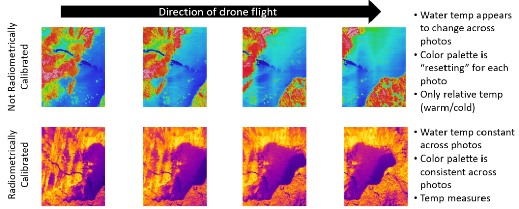
TIR sensors are either radiometrically calibrated or not calibrated. Uncalibrated sensors are generally cheaper and what you will find on most drones (unless it says it’s radiometrically calibrated, chances are it isn’t). Uncalibrated sensors provide relative temperature (hotter or colder), and may provide spot measures of temperature within the image. But, they are not intended for precise temperature measurements or for TIR photogrammetry. The challenges with uncalibrated TIR sensors are two-fold. First is that the color ramp applied to denote the temperature is typically reset for each photo (i.e., each photo will have the full range of colors from cold to hot). This can result in the temperature of an object appearing to change across multiple photos. The second challenge with uncalibrated sensors is that the output image files are usually just JPEGs of the color ramp and do not include actual temperature values. Radiometrically calibrated TIR sensors, on the other hand, will give consistent temperature readings across photos and will output images in either TIFF or R-JPEG file formats that preserve the temperature values.

For these reasons, it is important to use radiometric TIR images in photogrammetric applications and for creating orthomosaics.
In this lab, we will work through import, alignment, and creation of TIR orthomosaics. The main objectives of this lab exercise are to familiarize students with:
- File formats used for TIR imagery
- Processes for importing and aligning TIR images in Metashape
- Creation of TIR orthomosaics
- Raster transformations for converting image DNs to temperature values
Information on the conversion of TIR values to temperature in Metashape came from the following help doc: https://agisoft.freshdesk.com/support/solutions/articles/31000166933-processing-r-jpeg-data-in-metashape


